NANTAHALA HEADQUATERS LOOP- NORTH CAROLINA:
Coach Sheena's experience as a first time hiker/backpacker
This was an unforgetable trip for so many reasons and I'm excited to be able to share my story with you. But first this adventure had many moving parts and was made possible by a lot of people who I'd like to thank:
- Justin and Windy City Strength and Conditioning. Thank you for giving me the opportunity to get out of my comfort zone and experience something new. Thank you to my teammates Ox, Doc, Sam, Eloise, Austin and Cheston for covering my classes during the week I was gone. I truly appreciate each of you.
- Beefie (aka Servia). Thank you for all your hard work towards planning our route, packing gear, and travel. Thank you for not panicking when we got lost and thank you for being the best hiking buddy this girl could ask for. You're amazing.
- Sandy and Jay Wilson. Thank you for your hosptitality in North Carolina. You have a truly beautiful home filled with so much love!
The Adventure
I'm not much of a walker. I prefer my exercise to be exciting, short and intense and to the point. I've never really understood the value in "going for a walk". What's the goal here? Where and why are we going? How fast do we want to get there? Admittedly these same questions ran through my head when Servia first brought up the idea of going on a 3 day hike through the Nantahala Forest in North Carolina. I work out, I lift weights, I run (sometimes), how hard could it be? I grew up camping so I'm comfortable with the outdoors and I hadn't been camping in years so that part really appealed to me. I wanted to know what all the fuss was about. I really liked the idea of having everything we needed on our backs in our hiking packs. I also viewed this as a "step up" from hiking because we would be carrying 20lbs for 30+ miles. The challenge was set and I was ready to tackle it.
We chose the Nantahala Loop for several reasons:
- We loved the idea of hiking on the Appalachian trial.
- Being a loop, we would be able to have our parked car be the start and end of our adventure and eliminate the need for shuttles.
- The Nantahala forest foliage season would be near peak.
- We were told bear sightings were possible but not overly likely (win). As exciting as seeing a bear in the middle of the forest sounded, I was perfectly content to let my imagination provide all the "experience" with bears I needed.
- The Nantahala loop is a popular trail and there were printed maps available to detail our path.


SHOPPING!
Preparing for the hike was probably just as fun as the hike itself. We started from ground zero. It turns out Servia and I owned not one piece of equipment or apparel we would need for the trip. We got to researching and quickly begun “investing” in gear. REI was pretty much our one stop shop. We purchased backpacks, hiking boots, an ultra light backpacking tent, sleeping bags, trekking poles, jackets/rain shells, pants, dehydrated food and plenty of other necessities we didn’t know we’d need (like a jetboil camp stove for boiling stream water or hydration kits). The pros at REI were helpful and excited to take all of our money.
I was in charge of food (naturally). Servia and I both rigorously track our daily calories/macronutrients and we were not going to let a silly three day hike throw us off our respective plans! We figured out different foods we could bring and store in the Bear-Vault (an 11.5L plastic food bin that is nearly impossible for most bears and some humans to open). There is no way I was letting a bear steal my nutella wraps! We planned our three days worth of food in advance in MyFitnessPal and packed accordingly.
The Mountain House dehydrated meals were surprisingly tasty. Quest bars are a staple in my life so I was fine with 1-2 of these per day. I also stashed some tortilla wraps and nutella for snacks. Servia was a little more "healthy". She brought packaged tuna and ritz crackers. We were never short on food, but did have to make some adjustments on Day 1 and 2 which had some unexpected “surprises”.
The Hike
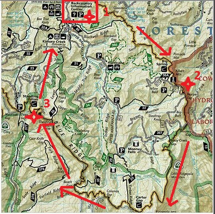
Our starting point was the Backcountry information center. Here we could park our car and begin hiking the loop on the Long Branch Trail. I can remember being both excited and very nervous. I really had no idea what to expect at this point. Servia and I had only done one "practice" hike (for about 30 min in the Chicago suburbs with 1/2 of our packs full). Let the adventure begin! We planned on a modest 5-mile hike en route to the observation deck on Albert Mountain where we would set up camp for the night. Spirits were high!
If you were paying close attention to the video, you would have noticed the arrow for Long Branch Trail pointing us directly left. This makes perfect sense now, but it was not clear then. I packed away my cell phone and we began walking straight ahead along the side of the paved road confident that the road was in fact “Long Branch Trail”. The correct directions (as indicated by the gigantic arrow) were to simply cross the road and enter the forest. Lesson 1: Pay close attention to the signs. Instead, we pounded the pavement full steam ahead for nearly 60 minutes without realizing we had possibly made our first wrong turn of the day. The trusty map we got from National Geographic had already failed us (because at this point it was the map’s fault). Servia had also experienced a minor setback while attempting to cross a flooded path. Nantahala 1, Servia's dry feet 0.
Right about now we realize we are lost. We had continued on this path/road until we came upon several signs seeming to indicate we were on or near Bear’s Pen Gap. We found Bear’s Pen Gap on our map and thought that rather than retracing our steps we could use an alternate trail to catch up to Long Branch Trail and ultimately onward to the Appalachian Trail (AT). We made the executive decision that this would be the quickest way to get back on track. Lesson 2: Be aware of trail crossing markers. Somewhere along our journey on Bear’s Pen Gap we crossed over onto another trail. We were lost and this time we could not find where we were on our map. Remember, at this point we were unaware of the fact that we had never actually started the day on Long Branch Trail. We also realized in hindsight that we had corrected our course at this point, but damn Bear Pen made us lost again We had been hiking for 2-3 hours on several different trails and had no idea how to connect to the AT!
It was not long until we stumbled upon trail markers which indicated that we were now on an "equestrian trail". The horse trails appeared to have some serious potential in being able to connect us to the AT if we navigated them correctly. The only thing standing in our way now was a healthy running stream spanned by a pretty sketchy looking log (nothing a horse could ever stand on). Though the log appeared to have enough structural integrity to get us across one at a time, Servia’s earlier plunge (and subsequent cold wet boots) made us briefly second guess whether the better decision was to backtrack several hours to the car and start our hike from scratch, or risk soaking all of our gear and being completely screwed. Being the athletes and adventurers we are, we moved on, shimmied across successfully (not gracefully) and eventually found our way onto the trail that would lead us to Albert Mountain.
I am purposefully going to omit all the detailed whining thoughts that ran through my head as we approached the end of day 1. When it was all said and done and we were finally on the top of Albert Mountain we had inadvertently hiked twice the distance we had planned (~10 miles). We reached the observation deck on Albert Mountain with just enough daylight to set up our tent (for the very first time), eat our first real "meal" of the day and briefly admire the amazing view of our surroundings. The rain had made setting up a campfire impossible so instead we wrapped ourselves up in our sleeping bags and crashed for the night.
Day 2 was an unforgettable day. We woke up just before daybreak and got to watch the sun rise over the valley while truly enjoying a cup of hot coffee (mine was a pumpkin spice Starbucks Via... you can't take the city out of this gal). We had made it through our first night without a hitch and by hitch I mean bears. Servia shared with me me later the she did see a mouse run across the top of our tent at one point, a trade I would gladly make.
We started to break down our tent and get ready for the day. While we were packing, a group of hikers came up the mountain to the observation point. These were the first people we had run into on the trail. We soon discovered that they were a family who had been through hiking the Appalachian Trail for the past 7 months. I’ll state that again... 7 months! They started in Katahdin, Maine and had just celebrated reaching the "100 mile to go" mark. Servia and I were completely awestruck. Here we were struggling after day 1 of our 3 day trip and the first people we meet had been doing this day in and day out for more than half of their year. The family explained many of the logistical hurdles of being on the trail for months at a time. For instance they had a family friend who would ship them supplies to predetermined points. We asked if they had any advice for us as newbies. The daughter, who may have been just 21 year old, really encouraged us to enjoy our surroundings. She said they had come into contact with many other hikers who had rushed through the experience "hiking for time" instead of savoring the moments. This was very wise advice which is why I decided I wouldn't try and explain that I understand the whole "for time" thing! Running into this family and hearing about their journey was truly inspirational and I would need it on this day.
Servia and I finished packing and this time made sure we were on the correct trail. Finding our way on the AT was much easier because the route is very well marked and maintained (and we learned how to identify trail markings from the day before). We had run short on water the night before so our first objective for the day was to find a stream and secure fresh rations. We found water quickly and set up our Jetboil stove for breakfast and more coffee. This was probably my most favorite memory of the trip. Not only was our view amazing, but I finally felt at peace in the woods. I'm sure my second pumpkin spice Via and blueberry granola breakfast had more to do with it than I care to admit!
Bellies are full spirits are high and we were ready to tackle our longest anticipated hike of the trip-16 miles to reach Standing Indian Shelter.
Being the prepared people that we are, both Servia and I had decided to download a bunch of music onto our phones for extra motivation during this long trek. We knew there wouldn't be cell phone service on most of the trail so we knew it would be critical that everything was stored. Lesson 3: Double check that your music had actually downloaded. When I fired up my phone I found that only 4-6 songs had seemed to make it through the downloading process. Servia suffered the same fate….and as luck would have it… the exact same 6 songs. (We love you Sylvan Esso, but not quite that much.) Looks like we were going to be alone with our thoughts for awhile. If you're wondering why we weren't more excited about each other’s company and conversation, the trails we were hiking were quite narrow and didn’t afford for much side by side walking. Servia was usually directly in front of me (clearing branches and stepping on stuff) so conversation had been kept to a minimum. When I couldn't stand the silence any more I would demand she slow down and talk to me!
About 8 miles in I hit a mental block. We approached a shelter that was to be our "halfway" point. By this point I was exhausted both physically and mentally. The thought of walking another 8 miles terrified me. I didn't want to take another step. We rested in the shelter for a few minutes and had a snack. I took this time to muster up some will power and decide that we were going to make it to our destination no matter what. Adding fuel to my new found fire, was an older gentleman at the shelter who made some "not so nice" comments about women that got me a little fired up. Apparently "Bumpy" (older gentleman) was surprised that women actually have the physical capacity to hike the AT. Bumpy continued to rest at the shelter while Servia and I (the women) laced up our boots and continued hiking.
Spirits are medium. We trudged along for what seemed like forever. I'm trying not to exaggerate here, but this was the longest most mentally grueling experience I think I've ever been through. I knew my body wouldn't fail me, but my mind had never been through anything more challenging. I was alone with my thoughts and no real clue as to how long this second leg of our trip was going to take. Our map wasn't overly detailed and neither Servia nor I really could judge how fast we were walking. Not to mention there not being any landmarks to indicate how far we’ve gone or how much we had left. It was just starting to get dark outside and we were once again off schedule. Luckily, we are two determined women (with ample “physical capacity” and thanks to Bumpy plenty of motivation) and were able to push through. The moment I smelled a campfire, I felt my heart leap. We finished day 2 at a shelter and quickly set up camp (in the dark).
Thankfully there was a stream close by and we were able to have enough water to boil for a proper dinner. I was pretty happy to be eating (surprise, surprise). I think Servia and I were both shocked how tough day two of our hike actually was on us. I'm so thankful we both place such a high priority on health and fitness. Our training at Windy City definitely prepared us for the physical rigors of this hike.
Day 3 was bitter sweet. I woke up that morning both excited to complete our journey but also sad that it was already coming to an end. The plan was a modest 5-mile hike back to our car and finish by mid day. We briefly entertained the idea of "taking the long way" but decided we probably had enough adventures on the trails for this trip. Servia was also growing short on patience from all the pictures I insisted on taking. It was a beautiful day and our packs were getting lighter from all the food we'd been eating! We made great time and ended up back at our starting point with ease. It was at this time that we revisited the "Long Branch Trail" sign and realized the errors of ways. I tried to capture some of this on video but was short on memory space so you can really only see a glimpse of it here. Live and learn I guess!
Wrapping it up
I am truly a humbled hiker. I wish I could convey how scary but safe it feels having everything you need strapped to your back. How satisfying it is earning the view of your surroundings and the food in your belly. How proud I am of my body for never quitting on me. It was truly amazing how small you can feel traveling the same ageless mountains that have witnessed the Civil War, and how modest your personal achievements seem compared to the mental and physical requirements of everyone else hiking further on the trail. Feeling small never allowed to me to feel so big.
Servia and I have plans to hike Machu Picchu in the future. These are grand goals, I know. I'm sure we will scatter in a few more weekend hikes before then, but for now we gained more than enough experience from our Nantahala journey to feel confident planning future adventures.
Thank you for taking the time to read about my experience! I encourage you all to get out there and experience your own #liveBIG adventure- whatever that may be!
